|

|
|
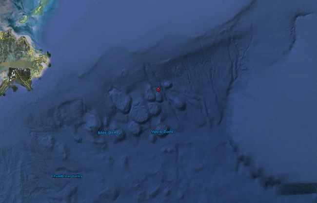
Tony Smith has compiled some information and pictures from Google Earth to give the Deepwater Spill some context
|
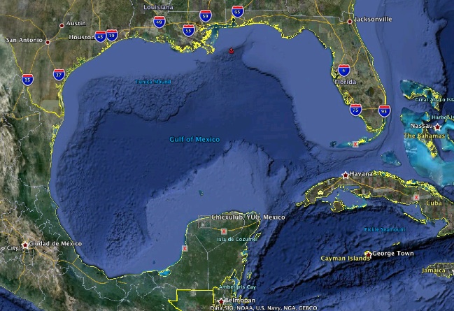
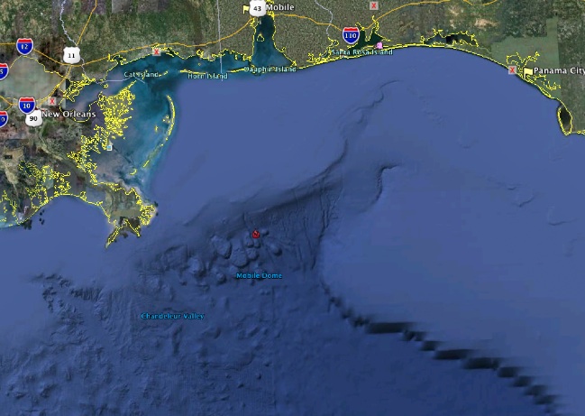
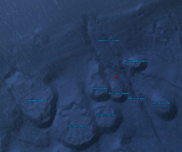
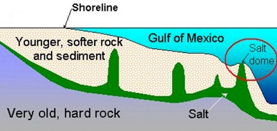
Explanation of what you see in regards to the Domes- Why they are there and Understanding how the Gulf of Mexico will be impacted with brine for years to come as a result of this spill, especially if rumors of ruptures in the Ocean Floor are correct. Going a step beyond the basic facts about the Gulf of Mexico in my previous message:WHERE DID THE SALT DOMES COME FROM ? On an oceanexplorer.noaa.gov Ocean Explorer web page dated 23 September 2003, John Bratton of the U.S. Geological Survey, Woods Hole, MA, said: "... the formation of the Gulf of Mexico ... began ... over 100 million years ago ... during the Jurassic Period when the granite core of the North American tectonic plate began to separate from South America and Africa ... big valleys ... start to fill as salt deposits form, like those found in the Dead Sea in Israel and Jordan ... These deposits are called the Louann Salt in the area of the Gulf of Mexico. ...As the big crack at the bottom of North America widened, the ocean filled the big valley permanently ... sediment began washing into the widening hole from the Mississippi, and other rivers ... burying a width of more than 500 km of salt ... Over millions of years, plumes of the light salt began to float up through the heavier sediment that covered it, like the colored liquid in a lava lamp. ... ... As the salt made it very close to the surface, sometimes having traveled through more than 10 km of rock and sediment, it pushed up the sea floor above it to form a mound or dome. ...". HOW DID BP GET INVOLVED IN GULF OF MEXICO DEEP-SEA OIL ? According to an aapg.org/explorer/ article by Kathy Shirley dated 3 March 2002: "... BP did ... some comparative analysis of the shelf's producing region and the deepwater... BP ... came to the conclusion that the deepwater could ultimately deliver at least 40 billion barrels of oil ... A couple of new developments occurred simultaneously with BP's research: Drilling contractors were developing a new generation of rigs that could drill in much deeper water depths. At that time the upper limit of the deepwater play was 5,000 feet and these new rigs could drill in 10,000 feet of water. The new generation rigs could drill to 30,000 feet subsea. The subsea limit at that time had been around 20,000 feet ...BP started looking at the possibility of deeper plays where the ... targets were subsalt ... larger, potentially simpler traps under the salt ... versus adjacent to salt. ...". So, while other oil companies were looking along the sides of the salt domes (above the salt layer) BP was smart enough to look under the salt layer, but as the image above shows, the salt was deposited over "very old, hard rock", so the question arises: HOW DID THE OIL GET UNDER THE SALT ? According to a humanevents.com article by Jerome R. Corsi dated 21 March 2006: "... Mexico’s richest oil field complex was created 65 million years ago, when the huge Chicxulub meteor impacted the Earth at the end of the Mesozoic Era. Scientists now believe that the Chicxulub meteor impact was the catastrophe the killed the dinosaurs, as well as the cause for creating the Cantrell oil field. The impact crater is massive, estimated to be 100 to 150 miles (160 to 240 kilometers) wide. The seismic shock of the meteor fractured the bedrock below the Gulf MORE>> |
|
Proponents of the abiotic,
deep-earth theory of the origin of oil point argue that the deep
fracturing of the basement bedrock at Cantarell caused by the
meteor’s impact was responsible for allowing oil formed in the
Earth’s mantle to seep into the sedimentary rock that settled in
the huge underwater crater. Geologists have documented that the bedrock underlying the crater shows “melt rock veinlets pointing to large megablock structures as well as a long thermal and fluid transport” as part of the post-impact history. In other words, the bedrock at Cantarell did suffer sufficiently severe fracturing to open the bedrock to flows of liquids and gases from the deep earth below. ...". Thomas Gold said, in his book "The Deep Hot Biosphere" (Copernicus Books 2001): "... Earth's massive reserves of hydrocarbons ... were part of the primordial "soup" from which our planet was created ... to this day they exist in abundance deep within our planet and continue to upwell toward the surface. ... Methane hydrate ... covers very large areas of ocean floor ...[there]... are sudden outbursts of gas from the ocean floor ... as in the eruption that caused a dvastating tsunami on the coast of Papua, New Guinea, in July 1998 ...". So, oil and methane were originally BELOW the "very old, hard rock", and when the Chicxulub impact hit the Gulf of Mexico 65 million years ago, it fractured the "very old, hard rock" and allowed the oil and methane to come up to the surface and form pools under the salt layer, which pools BP was smart enough to find,and in April 2010 the oil and methane blew out the BP Gulf of Mexico well. WHAT DID THE METHANE HAVE TO DO WITH THE BP WELL BLOWOUT ? According to a guardian.co.uk article by David Sassoon dated 21 May 2010: "... The vast deepwater methane hydrate deposits of the Gulf of Mexico are an open secret in big energy circles. ... For the oil and gas industry, the substances are also known to be the primary hazard when drilling for deepwater oil. ... Methane hydrates are volatile compounds — natural gas compressed into molecular cages of ice. They are stable in the extreme cold and crushing weight of deepwater, but are extremely dangerous when they build up inside the drill column of a well. If destabilized by heat or a decrease in pressure, methane hydrates can quickly expand to 164 times their volume. Survivors of the BP rig explosion told interviewers that right before the April 20 blast, workers had decreased the pressure in the drill column and applied heat to set the cement seal around the wellhead. Then a quickly expanding bubble of methane gas shot up the drill column before exploding on the platform on the ocean's surface.
Scientists are well aware of the awesome power
of these strange hydrocarbons ... their sudden escape is
considered to be a threat comparable to an asteroid strike or
nuclear war. The Lawrence Livermore National Laboratory, a
Livermore, Ca.-based weapons design center, reports that when
released on a large scale, methane hydrates can even cause
tsunamis. ...". I hope some of the above background information might be useful. |
New Index page for the oil spill -
Web producer Jane Swartley